ANS Finland, Finland’s air navigation service provider, outlined its vision of a national UTM system at the second meeting of the U-Space Network of Demonstrators, in Brussels, Belgium on 1 February 2019.
“There is a need for one national UTM service provider as an umbrella organisation,” said ANS Finland’s Pasi Nikama. “All other UTM service providers can join via open APIs.”
ANSPs have all the information needed and the capability to act as national UTM service providers, including real time data and the same level of services, said Pasi Nikama. ANSPs will make this digital data available via an open interface for business users and officials, via cloud services and micro services. This data includes:
- Shared information on drones and their intentions
- Same data for all – airspace model, airspace reservations, airports ops hours, other traffic
- Traffic information on all traffic
- Static data, dynamic data, including real time airspace reservations
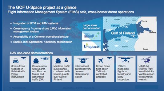
This is relationship structure underpins the Gulf of Finland (GOF) demonstration research programme, under development by ANS Finland, Estonian ANS, AirMap, Altitude Angel, Fleetonomy, Frequentis, Robots Expert, and Unifly.
“U-space needs to enable serving all airspace users in the airspace from the very starting point of its implementation, irrespective if the U-space services offered are AIS or active air traffic management.” Said Jonas Stjernberg Robots Expert Finland Oy. “The market is changing from one vendor serving all airspace in a FIR to shared responsibility of the airspace with increasing competition…However, master data architecture must be right from the start: one source of ADQ authority real-time airspace information is needed serving all aviation stakeholders. Reliability and cyber security requirements and compatibility and conformance testing is needed.”
So what services will independent UTM service providers actually provide? According to the GOF model these would include precision weather, 3D mobile coverage charts, dynamic charts and aggregation of people.
Other early GOF conclusions are:
- Need for a new way of quantifying airspace by U3/U4 u-space
- ANSPS have to invest in digital architect skills and drive, not outsource, digitisation
- Tactical geo-fencing, de-confliction and positioning rely on low latency, reliable data links
- 5G will not be a solution in rural areas
- Manned aviation must have access to u-space information when airborne
(Image: GOF targets and concepts)


