Researchers in Japan testing UTM and drone operating concepts at the Fukushima Robot Test Field have issued a request for information for UTM suppliers to provide an API-based drone traffic management system. According to the specifications document:
“In the Drones and Robots for Ecologically Sustainable Societies (DRESS) project, we are currently preparing to conduct interoperability tests on drone traffic management at the Fukushima Robot Test Field, as part of our R&D effort. As the first step, we have released the API specifications of the “Drone Traffic Management System.”
“By using the API, domestic and foreign drone operators who have not participated in the NEDO project will be able to conduct interoperability tests with Drone Traffic Management System at the Fukushima robot test field. We are planning to release test tools for the API and hold a briefing about them at the Fukushima Robot Test Field in 26 July. Our current plan is to start operating the Drone Traffic Management System API in order to conduct interoperability tests at Fukushima Robot Test Field in 30 August.
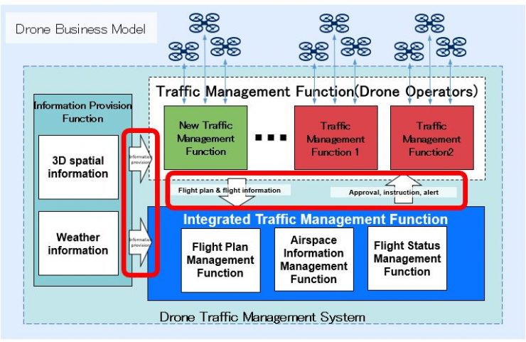
“The “Drone Traffic Management System” is a system that provides collision avoidance support when various drone operators fly their drones in the same airspace and safe traffic control considering the terrain and weather conditions.
“The following two functions can be used when connected to the Drone Traffic Management System API. This API also allows you to participate in the interoperability tests that are being conducted as part of the DRESS project at the Fukushima Robot Test Field. Consider using this API if you plan on verifying safety measures for drone operation.
“Safe drone flights can be achieved by sharing flight information of drones flown by multiple operators and receiving warnings and airspace information.
- You can check that your flight plans do not interfere with the flight plans of other operators.
- You can share your drone’s real-time position with other operators for safe drone operation.
- You can receive alerts when there is a dangerous situation and implement countermeasures.
- You can refer to and utilize airspace information for safe drone operation.
“You can fly your drones safely by using this API to receive 3D terrain information for the Fukushima Robot Test Field and surrounding area and detailed weather (wind and rain) information for drones.
The Fukushima Robot Test Field is a demonstration test base for robots and drones, technologies utilized in the fields of distribution, infrastructure inspection or disaster response, in which mock-up facilities for testing the robots and drones in practical environments are provided, including runways and flight test sites for drones, tunnels, bridges, mock-up city areas, and large reservoirs.
“Communications tower, a multi-function facility including flight-control, in-flight monitoring, long-range and inter-drone communication and weather monitoring can ensure safe drone flights across the flight zone. The test field is approximately. a 13-km area, a “wide-area flight zone” stretching between Minamisoma City, where the RTF is located, and Namie Town to develop an environment for smooth implementation of drone tests.”
For more information


