High Lander, a provider of drone fleet management and uncrewed traffic management solutions, has signed a distribution partnership with BODA, a prominent South Korean drone
Read more
The information portal for unmanned air system traffic management (UTM) and counter-UAS (C-UAS) systems

High Lander, a provider of drone fleet management and uncrewed traffic management solutions, has signed a distribution partnership with BODA, a prominent South Korean drone
Read more
The US Army’s W6J1 RCCTO BELVOIR office is seeking industry white paper responses to its requirement for an enduring directed energy weapon requirement. Deadline for
Read more
The latest update to the 500 page plus Global AAM/UAM Market Map database now includes details on 249 individual advanced/urban air mobility programmes in 60 countries throughout
Read more
The European Union Aviation Safety Agency (EASA) has published its Easy Access Rules for Unmanned Aircraft Systems (Regulations (EU) 2019/947 and 2019/945) The new publication
Read more
During the night of 8-9 July, the first set of test flights were carried out using drones with vertical take-off and landing capabilities to transport
Read more
According to the European Union Aviation Safety Agency (EASA)’s new Annual Safety Review for 2024 there was one fatality and one case of a serious
Read more
The United States Air Force (USAF) Counter small-Unmanned Aircraft Systems (C-sUAS) branch is requesting information regarding Electro-Optical/Infrared (EO/IR) camera technologies related to combatting the sUAS
Read more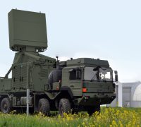
HENSOLDT is providing support for the German ‘European Sky Shield Initiative’ ESSI: As part of an order from Diehl Defence worth more than EUR 100
Read more
Mary-Lou Smulders, Chief Marketing Officer and Head of Government Affairs, Dedrone Summer is the peak travel season in the US, and 2024 is no exception.
Read more
Slovakia’s Mám Dron association has published the latest results from the country’s integrated ATM/UTM military system trials. According to the association: “The technological partners of
Read more