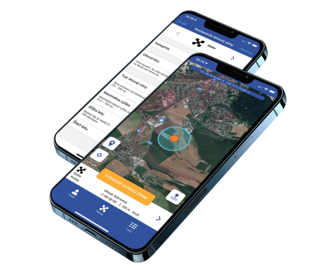
R-SYS of Slovakia has introduced a flight planning information system for drones called MamDron to provide drone pilots with access to data necessary to plan a flight. MamDron IS applications operate on iOS and Adroid mobile devices and are available free of charge to registered users in Slovakia.
According to R-SYS press information:
MamDron IS users are provided with tools needed for planning drone flights in a compliance with the applicable Slovak and European legislation in effect. Operations of drones (unmanned aircraft) are governed by several regulations restricting or prohibiting drone flights in certain portions of the airspace. Generally, such restrictions refer not only to airspace areas allocated for manned aircraft operations but also to an airspace identified by reserved areas on the surface, such as conservation areas, critical infrastructure, etc. MamDron IS role is to provide an access to this kind of data by use of just one SW application and through a single interface. Hence, upon submitting a flight plan (by specifying the operation category, flight route, duration and a purpose of the flight) the drone operator is clearly notified about specific conditions and limitations applied to the intended operation.
How MamDron Applications Work
The core of the mobile application is an interactive map showing to a drone pilot the zone allocated for his intended flight as specified in flight plan he can fill-in and submit with just a few clicks. A couple seconds after its submitting, MamDron provides all available information on possible constraints along the flight route including reserved areas and no-drone zones (where drone flying is temporary not allowed), and produces their visual representation on the screen of the pilot’s mobile device. Then, after a receipt of the related notification message, the pilot can check the zone availability for future flights. If the allocated drone zone overlaps with a reserved area or no-drone zone, the pilot can change his flight plan.
Which Inputs MamDron Uses
MamDron IS is designed in a way to collect a large amount of information on the reserved areas at the Slovak territory where drone flights are restricted or prohibited in accordance with specific conditions. The system is open and currently, following reserved areas and facilities are included in its database:
- Airports and areas around airports (ATZ/CTR)
- Nature conservation areas
- High voltage transmission lines
- Highways and expressways
- Military facilities and airspace allocated to Air Force operations
- Facilities/buildings in residential areas that are considered to be of a special interest.
MamDron application is designed for a dynamic creation of no-drone zones within which flight of drones is temporary not allowed, usually due to security concerns of large-scale events (such as VIP events, sporting events, concerts, military exercises, etc.) requiring its closure for a specified time period. Up-to-date information on Slovak no-drone zones is available at: https://mamdron.sk/aplikacia-mamdron/.
In addition, MamDron users can benefit also from an access to information about no-drone zones as specified by municipalities collaborating with the MamDron producer. Generally, such no-drone zones may include kindergartens, play grounds, hospitals or other places that may be endangered by drones flying over them, mainly for privacy, safety or security reasons. MamDron also notifies the drone pilot about a risk of its collision with another drone using the same zone, and provides information about a current weather in specified drone zones.
“When developing MamDron IS we paid a close attention to an integration of all available data set out by both Slovak and EU drone regulations for drone operation. We have even invited municipalities to participate at this project and to identify local zones they want to restrict or exclude from drone flying. MamDron is not intended to put limits on drone operation, but on the contrary, it is aimed at its safe integration into the manned aviation to support drone usage for commercial purposes. We plan to enhance the system by features providing drone identification, real-time tracking of drone movement, as well as drone flight control through use of artificial intelligence. ” said Marek Náhlik, CEO, R-SYS Ltd.
The MamDron project was initiated by the “Mám Dron” civil society having an ambition to promote and push ahead an ethical and responsible use of drones in Slovakia. However, turning this idea into a reality assumed, among others, an availability of IT solution that would provide drone users with information on air traffic situation while drawing attention to areas within which drone flights are restricted or even prohibited. To this end, the society turned upon the R-SYS Ltd, having extensive experience in a development of air traffic control systems to support this activity by a delivery of an unmanned aerial vehicle management system, which under the name MamDron will soon be introduced to Slovak aviation community.
“We are pleased that the R-SYS Ltd undertook to support our ambitions aimed at enforcing a responsible use of drones in Slovakia, and thus at improving a safety of unmanned aircraft operations by a delivery a SW solution designed for such purpose. We, at “Mám Dron”, consider it a huge step forward as it contributes to not only efficient and safe use of airspace, but also to a social acceptance of drones, and to an expansion of commercial use of drones in the very near future. Our strategy is to make the MamDron App accessible to as many drone users as possible since it represents a flight planning tool complying with applicable drone rules adopted by the concerned Slovak and EU authorities. We believe that this approach will be much appreciated not only by drone pilots but also by the general public not always perceiving drones positively.” … said Maroš Chromík, Chairman, “Mám Dron” Civil Society.
For more information visit:


