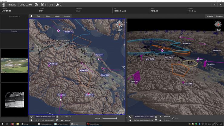
A partnership between Kongsberg Geospatial, Aireon and uAvionix plans to demonstrate how a space-based ADS-B feed can be fused with an ADS-B local receiver to create a “horizonless air picture” for BVLOS operations. This is important for long-range, BVLOS missions where unmanned aircraft systems (UAS) operators need to be aware of air traffic and other unmanned systems – both in the mission area, and over the horizon, says the press release.
This combined sensor picture is correlated within the Kongsberg geospatial IRIS Airspace Management application using local accuracy and updates from the uAvionix PingStation ADS-B receiver, as well as space-based Aireon ADS-B satellite receiver network. This integrated and correlated airspace picture provides highly accurate local coverage while eliminating local blind spots caused by terrain or obstacles while providing an over the horizon capability to monitor your own or any other ADS-B emitting aircraft, according to the release.
“Complete awareness of the air picture in your mission space increasingly requires knowing what’s over the horizon for long range unmanned flights”, explains Paige Cutland, Vice President at Kongsberg Geospatial, and one of the presenters. “By combining local ADS-B transponder data with a space-based feed, we can effectively create a ‘horizonless air picture’ so operators are aware not only of traffic in their immediate area, but what’s in the air beyond the immediate sensor range of their equipment.”
The partners plan to demonstrate how the horizonless air picture can help improve drone operations safety in an upcoming online seminar hosted by the Association for Unmanned Vehicle Systems International (AUVSI). The seminar takes place on Wednesday, February 3rd, 2021 at 3:00pm EDT by AUVSI, and a link for registration is available here.
Cyriel Kronenburg, Vice President International Development & Strategic Partnerships at uAvionix will describe how uAvionix’s PingStation2 multi-channel sensors can provide a real-time picture of nearby air traffic – both for commercial aircraft and unmanned systems.
Demetrius Zuidema Manager of Commercial Data Services at Aireon, will be providing information and examples of the near real-time air traffic data available from Aireon’s space-based ADS-B data feed.
The presentation will feature examples and scenarios of how both services can be integrated into a single operating air picture for situational awareness for UAS operators who conduct BVLOS operations.
(Image: Screenshot demonstrating how the IRIS UxS ground control station shows a mixture of real-time contacts from local sensors with near real-time contacts provided by a space-based data feed. Kongsberg Geospatial)
For more information visit:


